You probably already know that a compass and a paper map are part of the Ten Essentials. Understanding topo maps (short for topographic map) is every bit as essential. Your map can tell a richly detailed story about the area you’ll be exploring. We just have to open our eyes to see that story.
Understanding Topo Maps
As published in the February 2020 issue of Western Mule Magazine
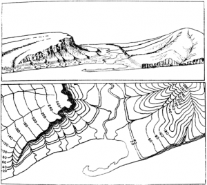
Have you ever looked closely at the squiggly lines scattered over your topo maps? Besides the obvious trails and rivers, the brown squiggly lines are contour lines. These fascinating lines represent the three-dimensional landscape of Earth within the two-dimensional space of a map. Contour lines give us 3-D glasses.
Topographic trail maps are useful for trip planning AND for navigation in the field. They give you the power to visualize three-dimensional terrain from a flat piece of paper. The feature that makes this possible is contour lines:
What these unassuming lines do is plot the points of equal elevation on a map. If you were to trace the length of a contour line, each point would be the same height above sea level. If you were to walk the path of a contour line in real life, you would remain at the same elevation for the whole hike. You might be hanging from a cliff by your fingertips but you would never go up or down.
How Contour Lines Describe Terrain
Simply put contour lines indicate the steepness of terrain. Where they’re close together elevation is changing rapidly in a short distance, therefore the terrain is steep. Where contour lines are far apart the elevation is changing slowly, indicating a gentle slope. There you go! A basic way of understanding contour lines!
Common Terrain Features
Contour lines also indicate the shape of the terrain. Major terrain features that you’ll find include Peaks, saddles, valleys, and depressions, and they each have characteristic contour lines that make it easy to pick them out in the landscape. Learning to identify the distinct features of common contour line patterns will help you read topo maps quickly, and recognize the various terrain features they represent on in the real world.
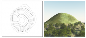
Peak: A peak, or hill is an area of high ground. From the top, the ground slopes down in all directions. Peaks are illustrated by contour lines forming concentric circles. The inside of the smallest closed circle is the hilltop.
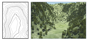
Valley: A valley is a stretched-out groove in the land, usually formed by a water feature, that has high ground on three sides. Valleys are illustrated by contour lines forming U-shaped or V-shaped patterns. The closed end of the contour line (U or V) always points upstream or toward high ground.
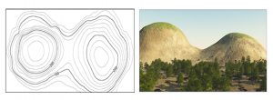
Saddle: A saddle is a low point between two areas of higher ground.. A saddle is illustrated by contour lines that typically looks like an hourglass.
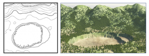
Depression: A depression is a low point on the ground. It could be described as simply a hole in the ground that isn’t a lake. Depressions are represented by closed contour lines that have tick marks (hachure lines) pointing toward low ground.
Becoming proficient in understanding contour lines takes practice. One of the easiest ways to do this is to become aware of the shapes of the surrounding land at all times, even when riding at your local park. Most navigation and map reading is about matching up the form of the land with those on the map. Pick out features like peaks and saddles on your ride and find them in the world around you.
Come to a TrailMeister trail clinic and learn more about using topo maps to plan trail rides as well as make sure that you’re back to camp in time for dinner!
As always for the world’s largest guide to horse trails and camps visit www.TrailMeister.com.
TrailMeister is the world’s largest horse trail and camp guide. With all of the info that you need on thousands of horse trails and camps across the US and Canada.