I know that we all have all been stuck inside to some degree but that should not stop us from planning our next adventure with friends. Who better to help us with that but Kim McCarrel and her informative Riding Oregon Horse Trails Books. Kim has graciously let me use some of her work and pictures to highlight a few places for us to explore and learn about. All 6 trails or camps listed below have been reprinted with permission from www.NWHorseTrails.com. All of Kim’s books can be purchased on www.NWHorseTrails.com that has much more trails and trail details than what I have provided below I encourage you to go check it out. Happy planning!
JOE GRAHAM AND CLACKAMAS LAKE HORSE CAMPS – NORTHWEST OREGON AREA
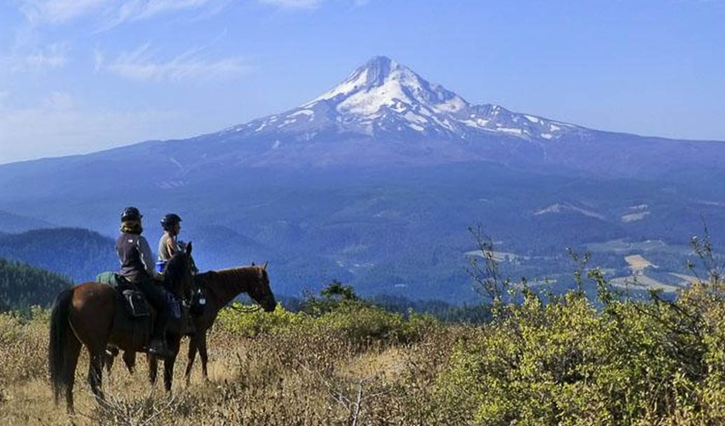
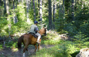
Are you starting to dream about fabulous summer riding? If so, and you want to go to Joe Graham or Clackamas Lake Horse Camps this summer, you need to make your reservations now. These popular camps on the south side of Mt. Hood have fabulous riding and they are relatively close to Portland, so the campsite reservations get snapped up early.
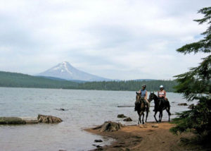
Both of the horse camps are near the shore of Timothy Lake, a sapphire jewel sitting at the foot of snow-capped Mt. Hood. They feature all the amenities you want at a horse camp, including log corrals, potable water, vault toilets, picnic tables, fire rings, and easy access to the trails. The trails in the surrounding area offer forest solitude along with beautiful vistas. You can ride all the way around Timothy Lake and take in its picture-postcard view of Mt. Hood.
You can make a loop using the Pacific Crest Trail and the Old 1916 Trail to reach the fascinating Little Crater Lake, which has a constant temperature
of 34 degrees year round. You can ride south on the PCT to the Warm Springs River. Or, if you’re into distance riding, you can go as far as you please either north or south on the PCT. The terrain is gently rolling, with moderate elevation changes and no steep hillsides to traverse. And the forest you ride through is both pretty and varied.
You’ll find plenty of riding at Joe Graham and Clackamas Lake Horse Camps for a long weekend summer of fun.
Getting There: From Sandy, OR, take Hwy. 26 west past Government Camp to the junction with Hwy. 35. Follow the signs toward Bend to stay on Hwy. 26. In 8.7 miles after the Hwy. 35 junction, turn right on Skyline Road (Road 42), drive 8.3 miles, then turn left into Joe Graham Horse Camp.
Or continue past the Joe Graham entrance for a short distance and veer left to stay on Road 42. In another mile, turn left into Clackamas Lake Horse Camp.
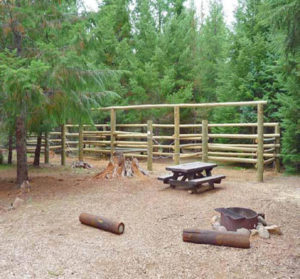
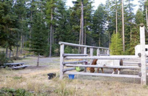
Camping Facilities: At Joe Graham, there are 14 sites with 2-, 3-, or 4-horse corrals. Clackamas Lake has 19 sites that allow horses, and 11 of these have 2-, 3-, or 4-horse corrals. All sites have picnic tables, fire pits, and parking for 1 trailer. You’ll find potable water and toilets at both camps. There is a Camping fee.
Reservations: Advance reservations are strongly recommended. Go to www.recreation.gov or call 877-444-6777.
GIBSON PRAIRIE HORSE CAMP – NORTHWEST OREGON AREA
Breathtaking views and delightful trails await you at Gibson Prairie Horse Camp, located at the base of Surveyors Ridge on the east flank of Mt. Hood. And this lightly-used horse camp is free of charge! The Surveyors Ridge Trail runs the length of the summit of its namesake ridge, and you can ride it either northbound or southbound from the horse camp. The trail offers eye-popping views of Mt. Hood from several vantage points along the way.
The trail is popular with mountain bike riders, so keep an eye out and be prepared to step off the trail if you need to. (OK, I know that bikes are supposed to yield to horses, but on this kind of terrain it’s often easier for the horses to get off the trail than for the bike riders.) And remember that cyclists who live in the city may not know much about horses, so be friendly and accommodating to our fellow trail users. The Horsemen’s Trails are a series of pleasant loop trails that explore the open forest and meadows around the horse camp. The trails use a combination of forest roads and single-track trails, and the terrain is gentle and horse-friendly. Most of the trails are unsigned, so you may want to carry a map and a GPS or compass. Plus, these trails are for horses only, so you won’t see any bikes.
The Watershed Boundary Trail is a relaxing ride that takes you through pretty mixed-conifer forest and open meadows to the boundary of The Dalles’ watershed, then along its perimeter for several miles. The trail runs along the top of a ridge, providing good views in both directions as you ride.
Fall is a great time to ride at Gibson Prairie, as the brilliant fall foliage of the vine maples contrasts beautifully with the golden grasses of the meadows and the deep greens of the forest.
Getting There: From Portland, head east on Hwy. 26. About 2.5 miles past Government Camp, turn north on Hwy. 35 toward Hood River. Continue 13.2 miles and turn right on Road 44. Drive 5.4 miles and veer left on Road 17. Continue 0.4 mile and make a 90-degree left turn to stay on Road 17. (Road 1720 goes straight ahead and is gravel.) The horse camp is 5.6 miles ahead.
From Hood River, drive south on Hwy. 35 for 14 miles and turn left on Pine Mont Drive, which becomes Road 17. Continue 9.7 miles to the horse camp.
Fees: None. The camp is maintained by volunteers from Back Country Horsemen
Season: Summer through fall
Camping Facilities: Five sites, three of which have 4-horse log corrals. Most of the sites are level and all are graveled. All sites have picnic tables and fire pits. The camp has a vault toilet, stock water from a trough, and a manure bin.
More Information: The trails out of Gibson Prairie Horse Camp are covered in more detail in Riding Northwest Oregon Horse Trails by Kim McCarrel, (Ponderosa Press, 2013).
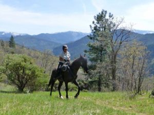
BADLANDS ROCK TRAIL – CENTRAL OREGON AREA
It’s the dead of winter, but today the sun is out and you’d like to go riding. Where can you go to find trails that aren’t icy or muddy? In Central Oregon, a great answer is the Badlands Rock Trail in the Oregon Badlands Wilderness.
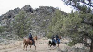
Located only 15 miles southeast of Bend, the Oregon Badlands Wilderness is 45 square miles of junipers, sagebrush, and bunchgrass accented by fascinating rock formations. The terrain is relatively flat, the tread is sandy, and the trails are open year round. All the trails are well signed. Created in 2009, the Oregon Badlands is a relatively new wilderness area. Its trails are mostly old roads created by the ranchers who once grazed their cattle on these BLM lands. The trails are all open to hikers, horseback riders, and off-leash dog walkers, but are off limits to mountain bikes and motorized vehicles.
The Badlands Rock Trail starts at the Badlands Rock Trailhead and runs 2.7 miles to its namesake formation. Badlands Rock is large basalt outcropping (technically a pressure ridge) that was created when molten lava flowed out of a lava tube and cooled, then was pushed up and fractured by more lava flowing out beneath it. If you want to ride an 8-mile loop, when you reach Badlands Rock turn left and follow the Castle Trail. It will take you to Castle Rock, then on to Flatiron Rock. Like Badlands Rock, Castle and Flatiron are basalt pressure ridges, but both have deep fissures that resemble moats in the tops of the outcroppings. You can tie your horse and scramble up the rocks and into the moats, which run all the way around the inside of the rock formations and offer nice views out over the treetops.
From Flatiron Rock, just follow the Flatiron and Homestead Trails back to your trailer. For a fun winter ride, check out the Badlands Rock Trail in the Oregon Badlands Wilderness. It’s memorable!
More details can be found in Riding Central Oregon Horse Trails by Kim McCarrel, and at www.NWHorseTrails.com.
PETERSON RIDGE HORSE TRAIL – CENTRAL OREGON AREA
One of my favorite places to ride is the Peterson Ridge Horse Trail, near Sisters. This trail has it all – panoramic mountain views, beautiful ponderosa pine forest, horse-friendly terrain, directional signs at every trail junction, and separate trails for horses and bikes.
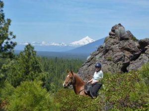
The Peterson Ridge Horse Trail is an out-and-back trail that runs the length of its namesake ridge. You’ll find three scenic overlooks that offer views of Mt. Jefferson, Mt. Washington, Black Butte, Three-Fingered Jack, the Three Sisters, and Broken Top. Plus, you’ll have mountain views from several
additional vantage points along the trail. The route is well signed, with white trailblazer diamonds on the trees and trail junction signs that indicate the distances and directions to various destinations along the route. The elevation changes are minimal and the trail is easy – the only minor challenges are a couple of irrigation canals that flow for about a month each summer.
The Peterson Ridge Horse Trail is open year round, though it may be too snowy to ride there at times in the winter. The trail can be dusty in summer (this is Central Oregon, after all), but you can minimize the dust by riding in pairs or trios instead of in larger groups. You’ll park at the Rodeo Grounds Trailhead, then follow the while diamonds on the trees. They’ll take you to the Peterson Ridge Overlook, the Eagle Rock Two Viewpoint, or the Peak View Viewpoint. Pick a destination and ride!
More details can be found in Riding Central Oregon Horse Trails by Kim McCarrel, and at www.NWHorseTrails.com.
BULLARDS BEACH HORSE CAMP- SOUTHERN OREGON AREA
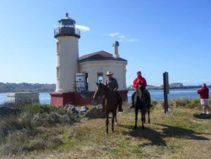
Bullards Beach Horse Camp is located at Bullards Beach State Park, 2.5 miles north of the town of Bandon. The park has a beautiful beach that offers splendid riding beside the surf, plus plenty of dune trails to add variety to your rides. Bullards Beach Horse Camp is open year round. It features eight
campsites with corrals tucked among the shore pines, potable water, garbage cans, and manure pits. You’ll find hot showers and flush toilets in the family campground just down the road, so Bullards Beach State Park has just about everything you need for a great horse-camping vacation any time of year. Reservations are required: 800-551-6949.
The Cut Creek Trail runs out through the dunes to Cut Creek, through vegetation that varies from dune grasses to dense stands of shore pines. You can create loops of varying lengths by turning off onto one of several trails that lead to the beach, and then riding back beside the surf. You can ride either down the beach or along a nice dune trail to reach the tiny but picturesque lighthouse located where the Coquille River empties into the Pacific. Tie your horse and take a guided tour of the restored lighthouse. Then ride back along the beach to complete a loop. The park opened a brand new trail through the dunes in 2012. It runs roughly parallel to the Cut Creek Trail, but farther inland. At the trail’s northern end it veers west and connects to the Cut Creek Trail, providing a delightful inland loop for days when the beach is windy or the tide is high.
Getting to Bullards Beach Horse Camp: From Coos Bay, drive south on Hwy. 101 for 22 miles. From Bandon, drive north on Hwy. 101 for 2.5 miles. All, turn west on Park Road. Continue 1 mile to the horse camp on the right.
More Information: Bullards Beach Horse Camp is covered in Riding Southern Oregon Horse Trails, by Kim McCarrel, (Ponderosa Press, 2014).
RIDING THE STERLING MINE DITCH TRAIL – SOUTHERN OREGON AREA
It isn’t often that you find a year-round riding area with miles of trail, But that’s exactly what you get at the Sterling Mine Ditch, a 20+ mile trail on BLM land just south of Medford.
In the 1850s gold was discovered in Sterling Creek. For years miners panned the precious mineral, but eventually the gold in the creek played out. There was still plenty of gold in the nearby hills, but getting at it under layers of rock and dirt was a challenge. Miners found they could extract the gold by using hydraulic jets of water to sluice away the hillsides so the gold flakes could be separated from the surrounding dirt. But hydraulic mining requires plenty of water, and there wasn’t an adequate water source nearby.
The solution was to construct a ditch to bring water to the mines from the Little Applegate River. In 1877, the Sterling Mining Company began construction. The nearly 400 mostly-Chinese laborers they hired dug a ditch 3 feet deep and 26.5 miles long, completing it in less than a year. The ditch remained in use until the 1930s, with mounted ditch riders patrolling it by riding along the berm. Their historic route is today the Sterling Mine Ditch Trail, which runs along the ditch (with a few detours around private property) for some 20 miles.
You can ride the entire 20-mile trail from end to end, or explore the trail in segments by riding out from one of five trailer-friendly trailheads. You can also create loops by parking at one trailhead, following its access trail to the Ditch Trail, riding along the Ditch, then taking an access trail to a different trailhead and returning to your trailer by riding on the lightly traveled gravel road you drove in on.
The Ditch Trail has little elevation change as it runs through shady stands of Douglas-firs and ponderosa pines, past groves of madrones and oaks, and across arid south-facing slopes covered with chaparral. In a number of places the trail offers expansive views of the Siskiyous and the Little Applegate Valley. You’ll also see remnants of the ditch’s past, from old log flumes to a hand-dug tunnel that carried the water under a hillside instead of around a ridge. What a delightful way to experience this area’s colorful history!
The Sterling Mine Ditch Trail is open year round, though it’s advisable to stay off the trail when it’s muddy to avoid damaging the trail tread. The trail is open to horses, hikers, and mountain bike riders.
More Information: Bullards Beach Horse Camp is covered in Riding Southern Oregon Horse Trails, by Kim McCarrel, (Ponderosa Press, 2014).
All of Kim’s books can be purchased at www.NWHorseTrails.com.
Article Submitted by: Sara Lagasse, Written by: Kim McCarrel for Back Country Horsemen of Oregon’s July newsletter
Kim McCarrel has been an avid trail rider for more years than she likes to admit, and has ridden the horse trails all over Oregon and SW Washington. Her books are must-haves for Pacific Northwest trail riders. They include “Riding Central Oregon Horse Trails,” “Riding Northwest Oregon Horse Trails,” “Riding Southern Oregon Horse Trails,” “Riding Southwest Washington Horse Trails,” and “Riding the Metolius-Windigo Trail.”